UPDATE: More BWCAW Closures In Northern Minnesota As Concerns Over Canadian Wildfires Increase
UPDATE: 07/19/21 - 7:30 am
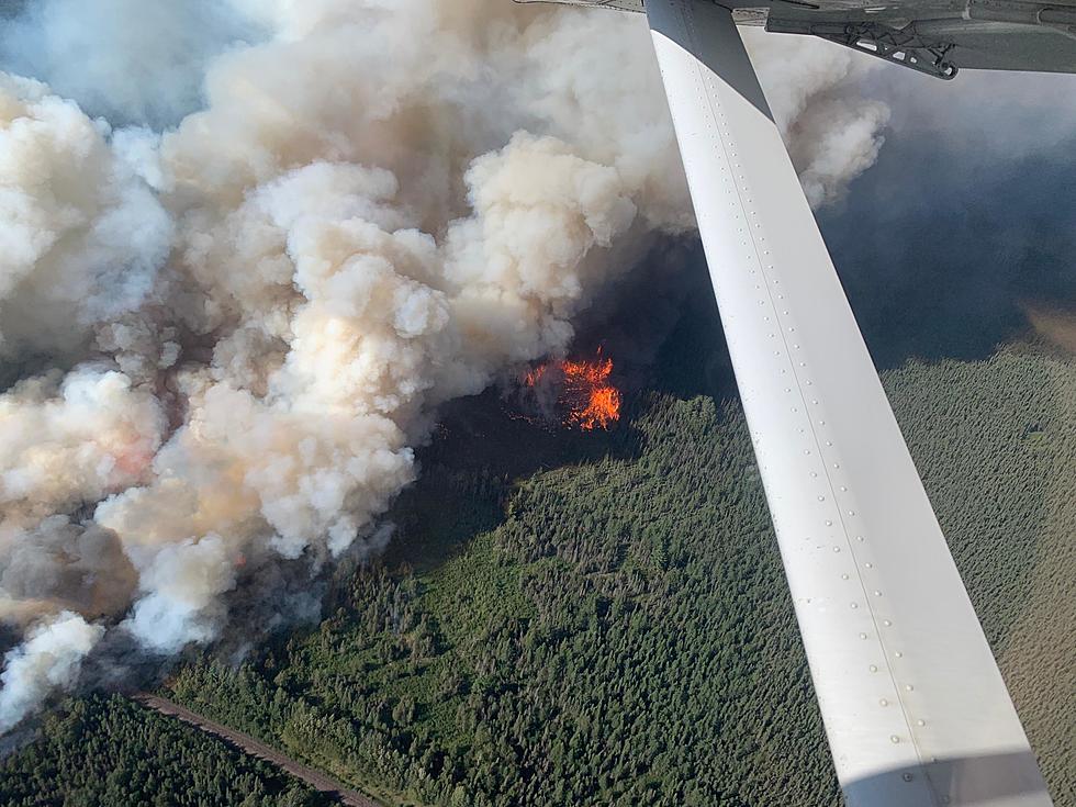
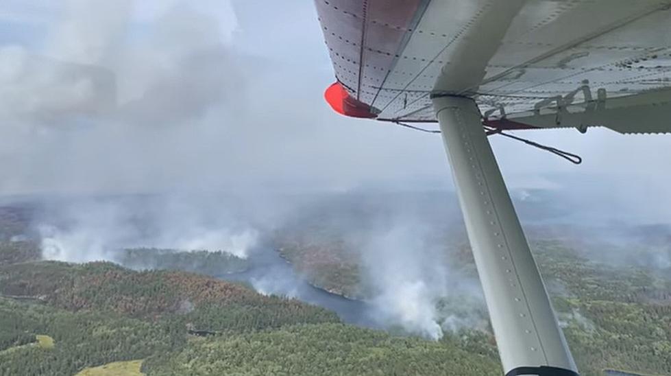
Additional closures have been added by the US Forest Service to the Boundary Waters Canoe Area near the Canadian Border as wildfires continue to blaze in Quetico Provincial Park
The USFS announced Saturday night that additional closures would go into effect on Sunday (7/18/21) as a preventative measure to keep people out of harm's way should fires spread across the border into Minnesota.
The new closures added to the list (see the original closures in the story below) include the following entry points:
- Little Indian Sioux River North #14
- Moose / Portage River #16
- Stuart River #19
- Angleworm Lake #20
- South Hegman Lake #77
- Little Vermilion Lake #12
- Lac La Croix Only #12A, Lac La Croix in and out of Canada #71
- Blandin Trail #11
- Herriman Lake Trail #13
- Sioux-Hustler Trail #15
- Angleworm Trail #21
They've also closed all trails, campsites, portages, and lakes accessed by the closed entry points noted above. Those closures include:
- Loon Lake
- Lac la Croix
- Ge-be-on-e-quet Lake
- Oyster Lake
- Shell Lake
- Hustler Lake
- Sterling Lake
- Ramshead Lake
- Lake Agnes
- Sterling Lake
- White Feather Lake
- Chippewa Lake
- Gun Lake
- Jackfish Lake
- Lake Agnes
- Fourtown Lake
- Horse Lake
- All zones of the Sundial Pristine Management Area (1 through 5), and the Weeny Pristine Management Area
You can see the full, updated closure map below, which includes the area just west of Basswood Lake all the way to well past Loon Lake.
Original Story: 07/15/21 - 7:31 pm
Officials with the US Forest Service announced Thursday afternoon that a portion of the Boundary Waters Canoe Area Wilderness will be closed starting this weekend due to fires across the border in Canada.
The notice details a series of closures near the Canadian border, all in response to fires in Quetico Provincial Park in Ontario near the Iron Lake and Crooked Lake area on the border.
The emergency closure order from the USFS explains that these closures are being put in place out of consideration "for the public's health and safety due to wildland fires in the vicinity". Due to the difficult nature of finding/contacting those in the BWCAW, the measure is being considered preventative in the event the fire spreads across the international border.

Closures go into effect on Saturday, July 17 and that the closures will remain in effect for at least 7 days, or until it is considered safe to reopen them.
The Forest Service shared a map of the area, but also provided a list (below).
Areas included in this closure include:
- Tick Pristine Management Area
- Sundial Pristine Management Area – Zones 1, 2, and 5
- #22 Mudro-Restricted Entry Point – No BWCAW entry.
- #23 Mudro Entry Point – No BWCAW entry.
- Iron Lake travel zone closure – From Bottle Portage/Bottle Rapids to Iron Lake and adjoining bays and islands of Iron Lake including Peterson bay and Three Island. Adjoining portages include the 320-rod portage west of Iron Lake from Lac La Croix, the 72-rod Dark Lake portage south of Iron Lake, the 110-rod Bear Trap River portage Southeast of Iron Lake, and the 140-rod portage to Curtain Falls.
- Crooked Lake travel zone closure – All campsites on Crooked Lake and adjoining bays from Curtain Falls to Lower Basswood Falls including Sunday Bay, Saturday Bay, Friday Bay, Thursday Bay, and Wednesday Bay. This includes the portage at Lower Basswood Falls.
- Campsites North of Gun Lake – Closure begins at the 300-rod portage Northeast of Gun Lake and includes campsites on Wagosh Lake, Niki Lake and Chippewa Lake.
Officials with the Forest Service will reportedly start initiating contact with visitors in the areas of the closure on Friday to instruct them to move away from the areas of concern that are being closed.
Anyone with permits reserved for these areas will be contacted and offered reimbursement/alternative options.
These new closures join an already existing closure due to the Delta Lake Fire near Ely. As of today's briefing on the fire situation, these entry points are closed:
- #56 – Kekekabic Trail East
- #74 – Kekekabic Trail West/Snowbank
And these lakes/campsites/portages are closed:
- Parent
- Adventure
- Rifle
- Disappointment
- Bridge
- Jitterbug
- Fire
- Ahsub
- Drag Primitive Management Area
- Becoosin
- Benezie
Fire restrictions within the BWCAW and across most of the Superior National Forest are already in place due to the ongoing dry conditions and limited resources to respond to additional fires. No campfires are allowed at all at this time in The BWCAW, while (as of the July 9 update) campfires are allowed in certain parts of the Superior National Forest, only within approved Forest Service fire structures.
11 Notable Twin Ports Weather Events From January To June 2021
Gallery Credit: Lauren Wells
KEEP LOOKING: See what 50 company logos looked like then and now
More From Sasquatch 92.1 FM