National Weather Service Issues Winter Storm Warning For Late Week Storm – UPDATED
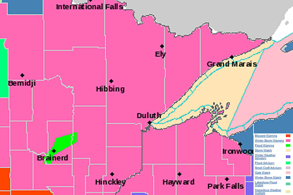
As the path of this week's storm becomes more clear, the National Weather Service has issued a winter storm warning for the Twin Ports and much of our region from 7 am Thursday morning through 1 pm Friday afternoon. A winter storm warning means significant amounts of snow, sleet, and ice will make travel very hazardous or impossible.
Accompanying this wintry precipitation will be strong winds, gusting upwards of 40 to 50 mph, which has prompted the National Weather Service to also issue a lakeshore flood watch from Wednesday night through Thursday night. Powerful waves are expected to batter the shoreline, which could lead to shoreline damage and flooding in some shoreline areas and places like Canal Park and Park Point. Adding to this are concerns for wave spectators. There is a sheet of ice floating around on Lake Superior, and the National Weather Service is warning that this sheet of ice could be pushed to shore and large waves could lead to this ice being broken up and flung ashore.
The latest timing for this storm looks to see light to moderate snow coming into the area early Thursday morning, and heavier snow coming in Thursday afternoon and continuing into the evening hours. There is a chance snow may change to a wintry mix or even rain at times in portions of the region. Snow will continue into the day on Friday, expected to taper off by Friday afternoon. Once again, there is a chance snow may change to a wintry mix or rain at times on Friday in parts of our area.
So, how much? It looks like it has the potential to be a lot. Assuming snow arrives on schedule and we don't see a changeover to rain that holds on for awhile, a foot of snow or more is possible around much of the region. A swath of 12-18 inches spans from Central Minnesota to the Twin Ports and North Shore, while the rest of the region sees 8-12 inches in the latest National Weather Service forecast. The big variables that could impact snowfall totals are if the strong wind of Lake Superior keep snowfall from starting as scheduled, or if we see more wintery mix or rain than anticipated. Those variables could reduce totals. We'll see what happens. In the meantime, here's what the National Weather Service is seeing for snowfall totals around the region.

More From Sasquatch 92.1 FM