Another Day Of Severe Weather For The Northland With Damaging Wind, Large Hail Possible Wednesday
The Northland is once again part of the biggest area of severe weather risk in the country, marking the second time this week our region has been at the epicenter of severe weather risk around the United States
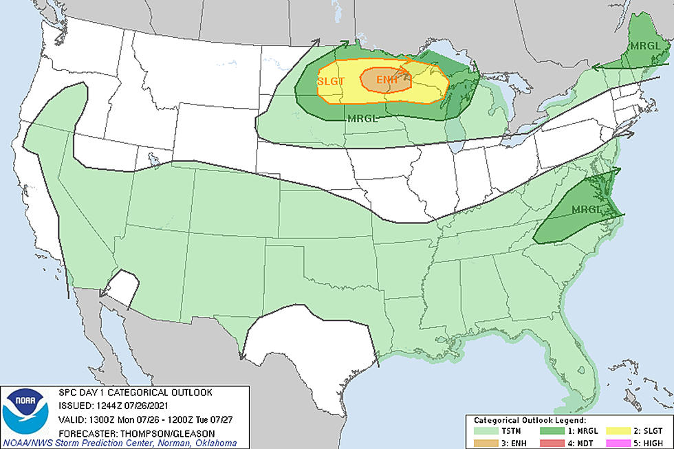
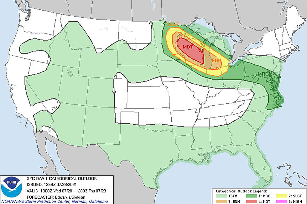
Like Monday, the Twin Ports area is again under an "enhanced risk" from the Storm Prediction Center. Unlike Monday, this is not the highest risk level for the region.
On the SPC's 5-point risk scale, "enhanced" is a 3 out of 5. A "moderate" risk area, which is 4 out of 5, has been issued for an area that includes Hayward, Hinckley and areas to the south and east like Eau Claire, Wausau, and areas down toward Appleton and Oshkosh.
The difference between these two threat levels is that areas in the moderate risk area have a greater chance of seeing long-lived and more widespread severe storms. The "enhanced" area indicates numerous and intense storms are possible, but less widespread potential than under the "moderate" level.

Regardless of your exact location around the region, much of the Northland does face a severe weather threat of some capacity, from portions of the Iron Range, through the Twin Ports area, and into the areas of Wisconsin, where the most significant widespread threat exists.
What are today's threats?
The National Weather Service explains that large hail and damaging wind are the most significant risks for the Twin Ports area, with high probability of both with some of today's storms. This is similar to Monday's storm event, where some places across the region did see up to baseball-sized hail and strong wind gusts.
In a breakdown of the individual storm threats, the Twin Ports area is included in the highest risk area for hail up to 2.75 inches in diameter. We are also included in the second tier (30% chance) of seeing damaging winds in excess of 75 mph, with the greatest risk into Wisconsin. They also point out that while the tornado threat is low, there is still a possibility of seeing some isolated tornado development. The Twin Ports area is included in the highest level of risk with these storms, with the greatest odds of seeing some weaker/short-lived tornadoes being within the first few hours of storms starting up.
There is also a threat of seeing localized flooding, with the greatest chance of that happening in the "moderate" risk area, but certainly not out of the question elsewhere.
The Duluth NWS office generated a model projection, showing a portion of Minnesota near the Duluth area could see some heavier rain as a part of today's storms, but the greatest chance of heavier rain is into Wisconsin.
When are the storms expected?
The National Weather Service office in Duluth explains that there is a threat of seeing some severe weather pop up through much of the day, with the heart of that risk period being between noon and 8 pm. While there is some timing uncertainty and a possibility of more than one round of storms, the NWS is estimating the timeframe for the greatest threat for severe storms in the Twin Ports area is between 3 pm and 6 pm. This is an updated timeframe from this morning, which suggested the biggest severe threat might be earlier in the day.
With today's storm chances across the region, be sure to be aware of any storm warnings and have a plan of what to do if things get intense where you are.
Must Have Items You Need In A Power Outage
Gallery Credit: Jeanne Ryan
10 Major Winter Weather Events In Northland History
More From Sasquatch 92.1 FM